A site record for a measured building survey. Record the method, the accuracy agreed and the control, and pin the building and each control point with GPS. Add each room with its length, width and height in millimetres (the form works out the area and volume), then each door and window with its size, sill and area, measured on the laser or from a photo against a door in the same wall. Elevation heights can be measured from a square-on photo as a check on the scan. The form counts the rooms, doors and windows and totals the floor and window areas. Try the form below, see every question or open a completed example.
✎Every question is editable. Add this form to your account, then change the wording, add or remove questions and options, and make it fit your own jobs.
A measured building survey records an existing building so accurate drawings can be produced, such as floor plans, roof plans, reflected ceiling plans, sections and elevations. The RICS professional standard Measured surveys of land, buildings and utilities has the client choose the outputs, the features to survey (walls, doors, windows, floors, ceilings, beams, columns and stairs by default) and the accuracy band, and connects every survey to a local or national grid.
Built for recording a measured building survey on site
Keep the site record alongside the instrument. Pin the building and the control points, enter each room in millimetres and the form works out the area and volume, and record every door and window with its size and sill. A photo against a door checks a reading or fills a gap, and the form counts the openings and totals the areas. It is a site record, not the drawn survey.
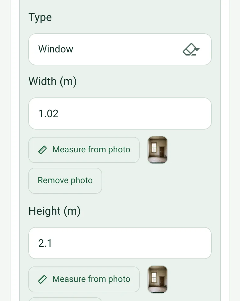
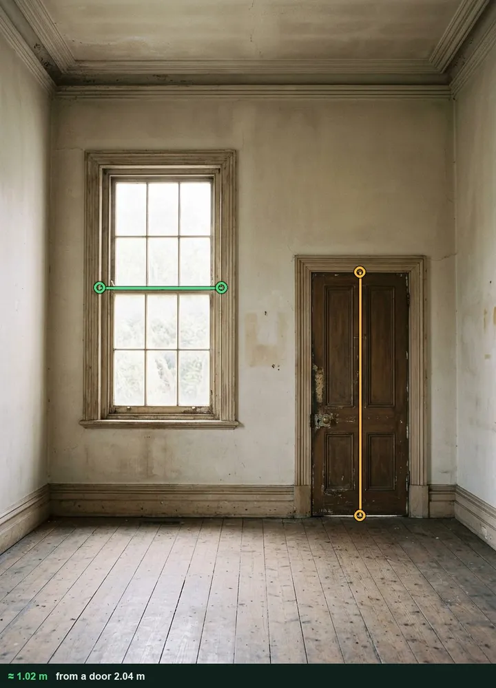
Openings measured from a photo
Add each door and window with its reference, width, height and sill. When a laser reading is lost, photograph the wall square on and measure the opening against a door in the same wall, then check it on the return visit. It works on web forms in any phone browser today, and the app version is on its way.
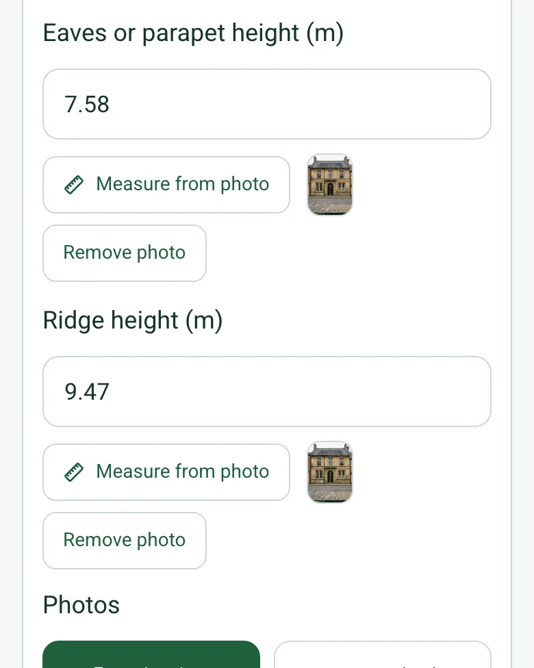
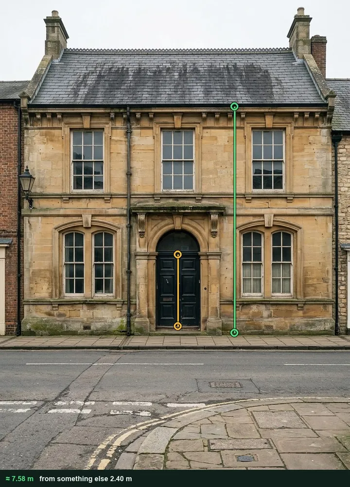
Take the elevation square on from across the street, with the front doors as the reference, and measure the eaves and ridge. It is an estimate to check the scan against, and the form shows the highest point recorded.
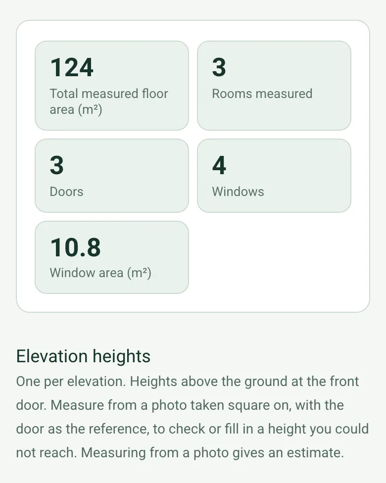
Each room's area and volume come from its length, width and height. The form counts the rooms, doors and windows and adds up the floor area and the window area for the drawing schedule.
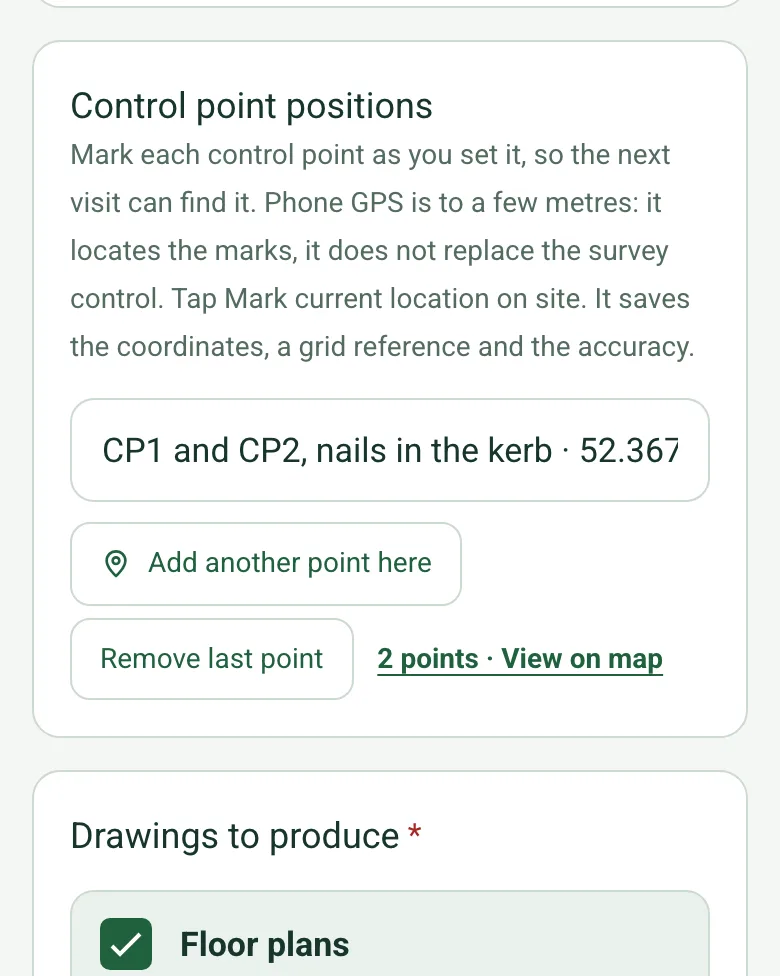
Mark each control point as you set it, so the next visit finds the marks. Phone GPS is to a few metres: it locates the marks, it does not replace the survey control. Mark current location works on web forms in any phone browser today, and the app version is on its way.
A fictional former library measured for a change of use: three rooms, the doors and windows on each wall, and the front elevation's eaves at about 7.58 m and ridge at about 9.47 m measured against the 2.4 m front doors as a check on the scan. Open it as a filled-in form, or switch to a blank copy and try it yourself.
This is the real form as your team would use it: questions appear as you answer, scores work themselves out and you can add photos and signatures. No sign-up needed. Or open a completed example to see every answer, photo and score filled in.
Every question in the measured building survey template
A measured building survey record: method and equipment, control, each floor and room with dimensions, heights, openings and features, services and photos, and the drawings to be produced. 3 sections and 48 questions. Follow-up questions and guidance appear only when an answer calls for them, so the person on site never sees the ones that do not apply.
✎
Make it your own: every question is editable
This is a starting point, not a fixed form. Once it is in your SiteSurvey account you can reword any question, add or remove questions, sections and answer options, and add your own logo, so it fits the way your team works and the jobs you do.
Details you only enter once
Add this form to a project in SiteSurvey and it fills in what the project already knows, so nobody on site retypes it and every form on the job uses the same names. Anything filled in can still be changed.
Project: the project name
Client: the project's customer
Site: the site, when the form is opened for a space or a product
Site address: the site address, from the space or the project
1
Survey
ProjectShort answer
Fills in from the project name
ClientShort answer
Fills in from the project's customer
Site*Short answer
Fills in from the site, when the form is opened for a space or a product
Site addressShort answer
Fills in from the site address, from the space or the project
Building locationShort answer
Mark it at the main entrance. Tap Mark current location on site. It saves the coordinates, a grid reference and the accuracy.
Survey date*Date
Surveyor*Short answer
Method*Tick all that apply
Laser distance meter and tape
Total station
3D laser scanner
Photogrammetry
Drone
Accuracy specified (for example the RICS accuracy band agreed)Short answer
Control and grid (control points, local or national grid)Short answer
Control point positionsShort answer
Mark each control point as you set it, so the next visit can find it. Phone GPS is to a few metres: it locates the marks, it does not replace the survey control. Tap Mark current location on site. It saves the coordinates, a grid reference and the accuracy.
Drawings to produce*Tick all that apply
Floor plans
Elevations
Sections
Roof plan
Reflected ceiling plan
3D model
GuidanceThe RICS professional standard Measured surveys of land, buildings and utilities (3rd edition) has the client choose the outputs, the features to survey and the accuracy band. Agree them before the survey.
Walk Cam: building walk-throughWalk Cam video with voice-to-text
Optional. Film a guided walk-through on the SiteSurvey app.
2
Rooms
Rooms
Repeat for each room. Each one asks:
Room*Short answer
FloorShort answer
Length (mm)Number
Measuring from a photo gives an estimate. Use it as a cross-check on your laser or tape figure.
Width (mm)Number
Measuring from a photo gives an estimate. Use it as a cross-check on your laser or tape figure.
Floor to ceiling (mm)Number
Measuring from a photo gives an estimate. Use it as a cross-check on your laser or tape figure.
Area (m²)Worked out by the form
Shown only when the answers above make it relevant
Volume (m³)Worked out by the form
Shown only when the answers above make it relevant
Doors and windows
Repeat for each entry. Each one asks:
ReferenceShort answer
For example D1 or W3, as it will appear on the drawing.
TypeChoose one
Door
Window
Opening without a door
Width (m)Number
Height (m)Number
Sill height above the floor (m)Number
Shown when “Type” is “Window”
Area (m²)Worked out by the form
Shown only when the answers above make it relevant
This room: doorsWorked out by the form
This room: windowsWorked out by the form
This room: window area (m²)Worked out by the form
Other notes on the doors and windowsNotes
FeaturesTick all that apply
Chimney breast
Beam
Column
Bulkhead
Stairs
Level change
Radiators
Sockets
Drainage
PhotosPhotos
Total measured floor area (m²)Worked out by the form
Rooms measuredWorked out by the form
DoorsWorked out by the form
WindowsWorked out by the form
Window area (m²)Worked out by the form
Elevation heights
Repeat for each entry. Each one asks:
ElevationShort answer
For example North (front) elevation.
Where it was taken fromShort answer
Mark the spot you stood on, so the photo can be retaken. Tap Mark current location on site. It saves the coordinates, a grid reference and the accuracy.
Width of the elevation (m)Number
Eaves or parapet height (m)Number
Ridge height (m)Number
PhotosPhotos
Highest point recorded (m)Worked out by the form
Shown only when the answers above make it relevant
3
Notes
Notes and limitations (rooms not accessed, furniture, roof spaces)Notes
Hand sketchesPhotos
Completed byWorked out by the form
Surveyor signatureSignature
See it filled in
A completed measured building survey report, made by SiteSurvey from a fictional site visit: every answer, the photos, the guidance that applied and the sign-off, ready to send as a PDF.
Laser distance meters and tapes for simple buildings, and total stations, 3D laser scanners or photogrammetry for larger or complex ones. The form records the method used.
Why agree the accuracy first?
RICS uses survey accuracy bands, and notes that capturing features at some bands involves additional work and may cost more. Agree the band and the drawings with the client before the survey.
Why record the control?
The RICS standard says all surveys shall be connected to a local and/or national grid. The form records the control points and grid used.
Does it work out areas?
Yes. Each room's area and volume are calculated from its length, width and height, each door and window gets its area, and the form totals the floor area, the doors, the windows and the window area. Photograph hand sketches into the form so they stay with the measurements.
Why record limitations?
Rooms not accessed, heavy furniture or unsafe roof spaces affect what can be drawn. Record them for the client.
Who uses this?
Measured building surveyors, architects, building surveyors and estates teams.